Introduction | Towns & Villages | Mountains | Landscapes | Buildings | Hiking | Plants & Animals | Photos
Towns and Villages: At the Roman Road and South of Sant-Julien-Chapteuil
About the Villages | Additional Information | Map | Photo Album | Hiking Tours | Links
This page introduces a couple of villages south of Saint-Julien-Chapteuil, some of which lie at an old roman road: Auteyrac, Le Betz, Noustoulet, Sabadel, Les Vignettes, Saint-Marsal, La Pradette (Haute, Basse)
About the Villages
When discussing the villages south of Saint-Julien-Chapteuil, I follow the old Roman road that comes from Saint-Germain-Laprade and continues to the east.
Auteyrac
The village of Auteyrac (approx. 820 m) is situated about 2 km southwest of Saint-Julien-Chapteuil and has only made it on this list because it is situated on a circular route, which we walk now and then from Sumène via Saint-Julien-Chapteuil and Auteyrac. Between Sumène and Auteurac, one crosses a ridge with pine forest, which is common in this area, and if we go down the ridge to the north towards D15 and Sumène, we have beautiful views to the west to Le Puy, to Eynac including rocks, to Saint-Pierre-Eynac with Madonna, quarry and Mont Plaux (1,032 m, several peaks), then on to the Monac (1,022 m), Mont Chanis (1,233 m, several peaks) and the mountains of the Meygal massif, such as Mont Mounier (1,407 m) and La Tortue (1,327 m). At some point, the church of Saint-Julien-Chapteuil and the town also appear. Before leaving Saint-Julien-Chapteuil and standing above the long cemetery, you will also have beautiful and closer views of the town and the church.
Auteyrac has a béate, a public oven, a few houses concentrated at the village meadow and some nasty dogs... Outside in the forest there is a large quarry, according to our map an "ancient" one, but according to our impression it is still in operation.
Noustoulet, Le Rivet, Sabadel, Les Vignettes
From Auteyrac you can go down a path to the southwest, which runs through a wooded area (one walks in the forest) and meets a variant of a Roman road at Le Rivet (796 m) - or you can go a little further and meet the Roman road itself at Sabadel (808 m). Both roads run south-eastwards through a pine forest, run towards each other and meet in Les Vignettes (909 m).
The Roman road comes from Noustoulet, which used to be on the D15 but is "cut off" by a new roadway. Coming from Saint-Germain-Laprade (about 670 m), the Roman road runs straight to the southeast. Between Noustoulet (726 m) and Saint-Germain-Laprade the new access road to the N88 to the north (Blavozy) is now partly on the Roman road. We parked in Noustoulet at the school to walk down the straight stretch to almost Sabadel, in front of which the Roman road moves a little off to the side. Sabadel and Les Vignettes consist of only a few houses, Le Rivet is a little larger.
La Chapelette, Saint-Marsal
In Les Vignettes, the choice is yours: either you go southeast to La Chapelette (926 m), where a small chapel overlooks a valley. Or you can go directly eastwards to Saint-Marsal (989 m), which is situated on the D49, which leads northwards via Le Betz to Saint-Julien-Chapteuil. Behind Saint-Marsal, the Roman road continues eastwards to La Pradette Haute, but not as straight as between Noustoulet and Sabadel.
La Pradette (Haute, Basse)
Before you reach La Padette Haute (1,061 m), the pine forest ends, on the right there is a cross (Croix du Puy), and if you continue on to the village, you have very nice views, especially to the north of the Meygal massif and Saint-Julien-Chapteuil. Similarly beautiful views can be enjoyed from the D150 when driving northwards to Saint-Julien-Chapteuil. In the centre of La Pradette Haute there is a béate, and if you go down a little to the south from the central car park, you have beautiful views of the Gagne valley. There also goes down a small road, but we've never driven it yet... La Pradette Basse (1,026 m) is located just north of La Pradette Haute and, as the name suggests, located lower. We crossed it once, but I don't know any more about it...
The D150 continues east to Boussoulet with a turnoff to Montusclat. It is situated above the Gagne valley and offers beautiful views over the valley, although less for the driver... We drive this road more often on the way home towards Saint-Julien-Chapteuil, whenever I don't feel like driving on the D15 with its many traffic...
We do not know exactly how the Roman road continues, because we could not find any information about it. At some point further east (behind Boussoulet) it seems to run along the D15 towards Valence, which is quite straight.
Le Betz
From Saint-Julien-Chapteuil the D49 leads south and forks before Le Betz (923 m). To the east, the already mentioned D150 branches off towards La Pradette Haute, first past the Boissy shoe shop (former shoe factory), which we have visited several times. Roughly southwards, the road continues to be called D49 and shortly after reaches Le Betz, which is a little bit spread out on the hill. The D49 leads further south to the aforementioned Saint-Marsal. Le Betz is probably best known for its observatory, which the group Orion43 operates there on an open area. The observatory itself is not large, but in front of it there are wooden chairs that make it easier to observe the sky. Events and performances take place there at regular intervals, but unfortunately we have only been able to participate in 2018 for the first time... From Le Betz you can walk northwest to Auteyrac (or get lost). In this direction there are also beautiful views, because Le Betz is higher than the area west of it. The area is characterized by pine groves, as on the entire Roman road.
Mountains
Mont Plaux (1,032, several peaks), Suc de Monac (1,022 m), Mont Chanis (1,233 m, several peaks), Mont Mounier (1,407 m), La Tortue (1,327 m)
Additional Information
Curiosities
- Observatoire de Betz (Observatorium, Orion43)
- Chapel La Chapelette
- Roman road
- Views of the Gagne valley (La Pradette Haute)
- Views towards Saint-Julien-Chapteuil and the Meygal massif (La Pradette Haute)
Facilities
-
Observatoire de Betz (Observatorium, Orion43)
Specialties
- Roman road
- Pine forests
Towns and Villages Near-by
Road Connections
- D49 to the south from Saint-Julien-Chapteuil to Le Betz and on to Saint-Marsal
- D150 to the southeast from Le Betz to La Pradette Haute and on to Boussoulet
- Road southwest from Saint-Julien-Chapteuil to Auteyrac
Curiosities in the Environment
- Saint-Julien-Chapteuil with its Romanesque church and other curiosities
Map
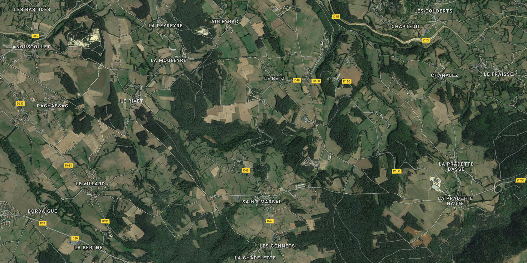
Photo Album
In preparation
Hiking Tours
| Starting Point | Length | Duration | Altitude |
|||||
| Number | Recommended | Alternative | Name | (km) | h:min | min | max | References |
| PR167 | St. Julien-Chapteuil | La Chapelette | 10 |
2:50 | 800 | 1026 | Le Pays des Sucs et du Meygal … à pied (11) | |
| PR167 | St. Julien-Chapteuil | Circuit de la Chapelette | 13 |
3:15 |
820 | 1059 | It. Péd. En Ht. Loire | |
| PR167 | St. Julien-Chapteuil | La Chapelette | 7.1 |
2:15 |
"Gertrude's" new brochure | |||
| PR186 | St. Julien-Chapteuil | Circuit de la Pradette | 9.5 |
2:25 |
820 |
1070 |
It. Péd. En Ht. Loire | |
| Magenta: Older version (Randonées pédestre et VTT au pays des sucs - Yssingeaux) | ||||||||
| Blue (italic number): Older version (Itineraires Pedestres en Haute-Loire) | ||||||||
| Red: New | ||||||||
Details:
- Respirando - Les sentiers de Promenades et Randonnées (PR) Respirando: www.respirando.fr/index.php/apied/les-sentiers-de-petites-randonnees-pr-respirando.html
Links
- Saint Julien Chapteuil (site de la commune, F): www.saintjulienchapteuil.fr
- Bienvenue au Pays du Meygal (F): www.auvergne-paysdumeygal.com
- Orion43 (Observatoire de Betz): www.orion43.fr
|
made by |
||
| 13.03.2019 |