Introduction | Towns & Villages | Mountains | Landscapes | Buildings | Hiking | Plants & Animals | Photos
Towns and Villages: Around the Suc de Monac
About the Villages | Additional Information | Map | Photo Album | Hiking Tours | Links
This page introduces a couple of villages around the suc de Monac: Le Collet, Mon(n)ac, Les Sauces, La Pouade, La Visade, La Freydeyre.
About the Villages
When discussing the villages around the Suc de Monac, I follow the roads and trails that we drive and walk.
Le Collet
The D28 coming from Saint-Julien-Chapteuil (after Pertius to the N88) has a turn-off to the left at a small pass, from where the D261 goes to Saint-Pierre-Eynac (it ends close to this village at the D26, which leads to the village). This street is a "panorama road" with very nice views of the Meygal massif and Saint-Julien-Chapteuil. The small village of Le Collet (884 m) lies at this junction, from where we usually continue our walk to Mon(nac), the village at the foot of Suc de Monac (1,022 m). Mostly we come from La Chapuze and followed the ruisseau (small river) de Merlan.
Mon(n)ac
The village of Monnac (843 m) is not situated at the D28, from which it has access, nor at the street to Saint-Pierre-Eynac, from which only paths (e. g. from Suc de Monac) lead to the village. Why the village is sometimes written "Monnac" and sometimes "Monac" is beyond our knowledge... Since the village is not located at any thoroughfare, it is quiet - and is largere than it seems at first glance. It has an assemblée/beate and a public oven. In the south, you have a beautiful view in the direction of Saint-Julien-Chapteuil (from there we typically continue our walk to Sumène and to our current camping site) and to the north you can, of course, see the Suc de Monac in various perspectives.
Les Sauces
If you return northwards to the road to Saint-Pierre-Eynac and follow it, you will reach the small village of Les Sauces (857 m). Here too, there is a public oven, and apart from that, the village and its surroundings offer magnificent views of the Meygal massif, the Suc de Monac, and Saint-Julien-Chapteuil. From here, there is a downhill path that crosses the road from Mon(n)ac to Sumène, which we walked often, and a road uphill that crosses the small street from Marcilhac to La Vizade (and further...). We also often walked along this road.
La Pouade, La Visade
At Marcilhac, a small street branches off the D28, heading west to La Vizade and further on. At first, however, you pass the small farm La Pouade (approx. 910 m), which often attracted our attention due to its busy poultry life, but also changed hands again and again. It used to belong to the brother of our camping site owner in Marcilhac. Later he owned a house in La Vizade, but still had a field near La Pouade, which he worked on. We often saw him there without knowing who he was. In the meantime, he has unfortunately passed away (just like our former camping site owner).
La Vizade (922 m) is a long village without any special features. From there, as already mentioned, a road branches downhill to Les Sauces. This road offers some very nice views. For this description, however, we continue to follow the road either to the left at the foot of the multi-peak Mont Plaux (1031/1032 m) in the direction of Saint-Pierre-Eynac (mostly in the opposite direction...), or to go on to a vantage point in the direction of N88 and Le Puy, then turn right and walk through the forest to La Freydeyre.
La Freydeyre
La Freydeyre is located quite high (968 m) and if you take the small street that you come across a little to the west, you will have another nice view towards the N88 and Le Puy. If you take the street a little bit to the east, you have a view of the deux Mézèzeres (1187/1202 m), two Sucs near Queyrières, which stand out with their large scree fields, particularly the bigger mountain of the two. We then go through the forest to the north and often make a detour to the Plaine de Faries plateau (1006 m), where mostly cows graze, so that we cannot enter it. If possible, you can go to the southern edge and have a nice view of Saint-Julien-Chapteuil and the Meygal massif. We then continue, left or right past the Suc de Monac - formerly to Marcilhac and now through Mon(n)ac back to Sumène....
Mountains
Suc de Monac (1022 m), Plaine de Faries (1006 m); Mont Plaux (1031/1032 m), Deux Mezeres (1187/1202 m)
Additional Information
Curiosities
- Assemblée/béate and public oven in Mon(n)ac
- Public oven in Les Sauces
- Views of Suc de Monac, Meygal massif, Saint-Julien-Chapteuil, to the west in the direction of Le Puy, to the eact to the Deux Mézerès (Sucs near-by Queyrières)
Facilities
- ---
Specialties
- ---
Towns and Villages Near-by
- Saint-Julien-Chapteuil
- Saint-Pierre-Eynac
- Marcilhac
Road Connections
- Access from the D28 to Mon(n)ac
- D261 starting from the D28 near Le Collet and ending at the D26 which leads to Saint-Pierre-Eynac
- Road from the D28 near Marcilhac to La Vizade and further on
- Road from the D28 to La Freydeyre and further on
Curiosities in the Environment
- Meygal massif
- Church and basaltique rocks of Queyrières
- Saint-Julien-Chapteuil with its Romanesque church and other curiosities
- Saint-Pierre-Eynac with its Romanesque church
Map
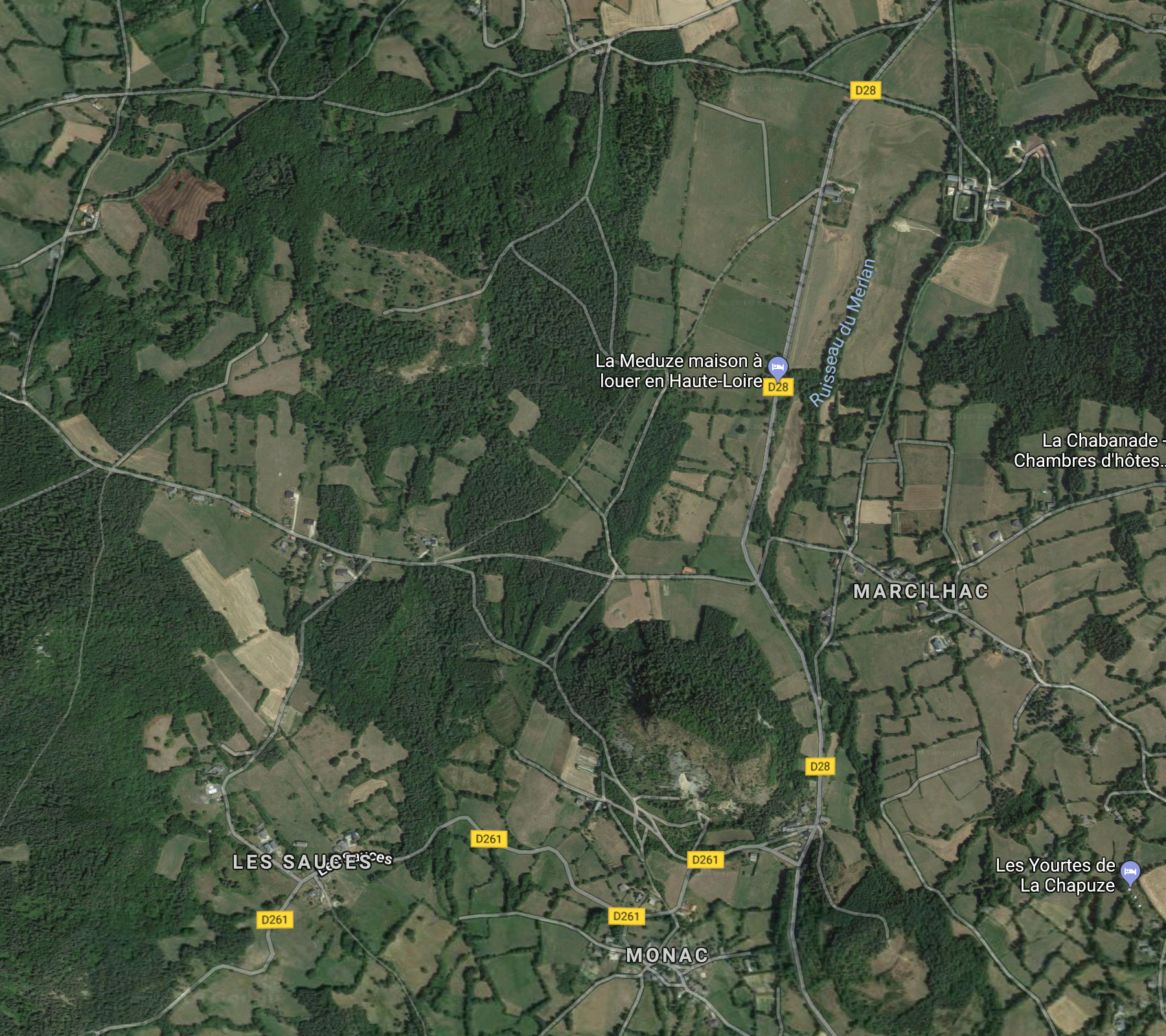
Photo Album
In preparation
Hiking Tours
| Starting Point | Length | Duration | Altitude |
|||||
| Number | Recommended | Alternative | Name | (km) | h:min | min | max | References |
| PR191 | St. Pierre-Eynac | Marcilhac | Circuit de Monac | 9,5 |
2:30 |
775 |
1020 |
23 – Autor de St. Hostien, sur le contreforts du Meygal (It. Péd. En Ht. Loire) |
| PR191 | St. Pierre-Eynac | Marcilhac | Autour de Monac | 8,5 |
2:30 |
768 |
1020 |
Le Pays des Sucs et du Meygal … à pied (15) |
| Magenta: Older version (Randonées pédestre et VTT au pays des sucs - Yssingeaux) | ||||||||
| Blue (italic number): Older version (Itineraires Pedestres en Haute-Loire) | ||||||||
| Red: New | ||||||||
Details:
- Respirando - Les sentiers de Promenades et Randonnées (PR) Respirando: www.respirando.fr/index.php/apied/les-sentiers-de-petites-randonnees-pr-respirando.html
Links
- Saint Julien Chapteuil (site de la commune, F): www.saintjulienchapteuil.fr
- Jules Romains (Wikipedia, DE): de.wikipedia.org/wiki/
- Bienvenue au Pays du Meygal (F): www.auvergne-paysdumeygal.com
- Suc de Monac - 43260 St Pierre Eynac (YouTube): www.youtube.com/watch?v=yMDjwUU1l-o
|
made by |
||
| 13.03.2019 |